

By Phil Greville, Data Scientist at Datarock
TL;DR: Open‑source GIS is now as capable as proprietary tools and handles big, complex datasets well. FOSS4G 2025 highlighted new innovations, strong community momentum and growing adoption. Datarock uses these tools and contributes to the ecosystem.
The Free and Open Source Software for Geospatial (FOSS4G) Conference returned to Auckland in November 2025. It brought together developers, researchers, and practitioners from around the world who use open-source tools to address practical geospatial challenges.
Key theme
One key theme this year was that the capability gap between open-source and proprietary GIS tools has largely closed. Open-source options now handle most standard workflows effectively and provide greater control to the user. This allows for customisation and easier integration. Discussions have moved from questioning whether open-source tools can meet needs to considering the advantages of using them.
Real-world value challenge
Another common theme was people/companies seem to have so much data available to them now through public data and new fast data collection tools but standard data analysis tools can make it difficult to get the full value from it.
The FOSS community definitely understands this problem and is addressing it by continuing to advance software capabilities to handle larger and more complex datasets.
Innovation in action
I saw two tools in particular that have recently been developed to address this particular problem:
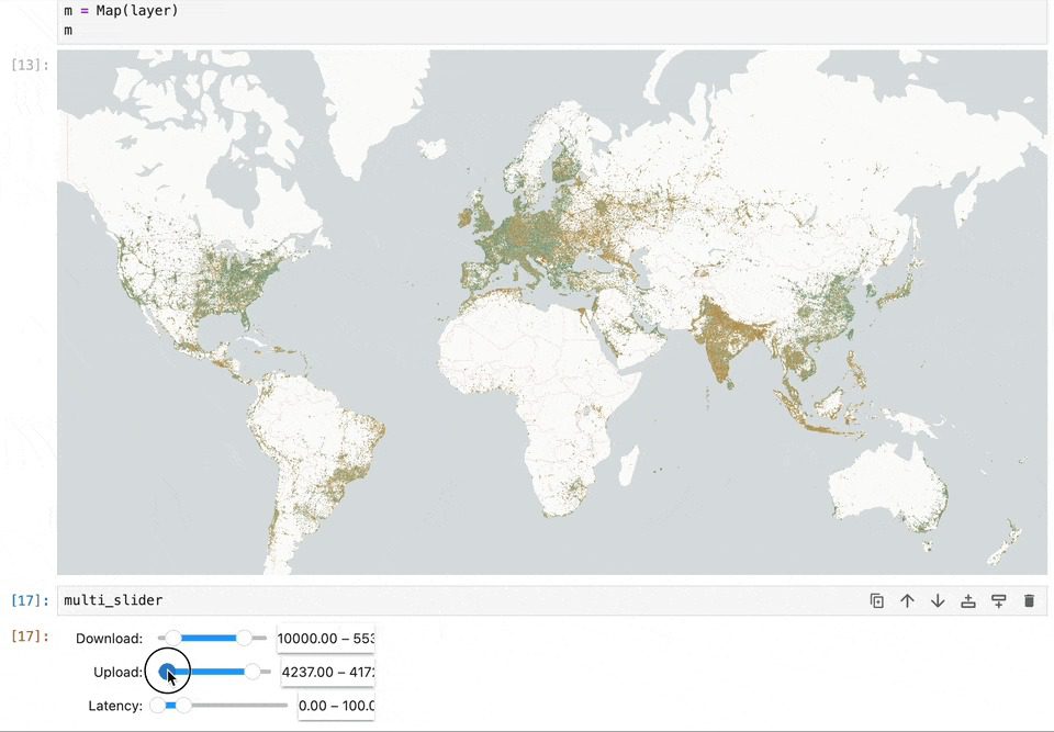
Lonboard, a Python library for visualisation, addresses the challenge of interactively exploring huge (GB scale) vector datasets. It performs well with high data volumes, supporting smoother analysis and better communication of results.
The i.hyper add-on for GRASS GIS makes hyperspectral imagery analysis more accessible, helping users work with detailed spectral data without steep barriers.
Datarock’s contribution
I presented a lightning talk on creative uses of open data. The discussion focused on the vast amount of publicly available data there is out there and how it can be used in fun and interesting ways.
The path forward
There are a lot of companies out there doing amazing things with open source software and it’s all freely available for anyone to use and build on top of. The community works best when everyone is involved, whether that’s contributing code, improving documentation, sharing workflows, or simply giving feedback from real-world use. When more people participate, the tools get better faster, interoperability improves, and everyone benefits.
FOSS4G 2025 showed that open-source GIS has reached a mature stage. The tools are capable, adoption is straightforward, and we are always looking for people to get involved and influence the future of open-source software.
At Datarock, we regularly use open-source geospatial tools in our work with resource-sector data. The current state of these tools aligns well with the need for flexible, scalable solutions in our field.
We’re excited to keep contributing where we can, and learning from the incredible work being shared across the open-source geospatial ecosystem. See you at FOSS4G 2026!
