

Datarock Core analyses your core photography, producing valuable geotechnical and geological datasets. Our software automates and augments your traditional logging and data generation workflows, allowing your core shed to work faster and smarter.
Datarock Core turns imagery into actionable insights
Request a demo

Flexible plan options
to fit every business
Check our FAQ, or contact us for pricing information.

Essentials
30,000m
Analytics-Ready Data
Geotech Bundle
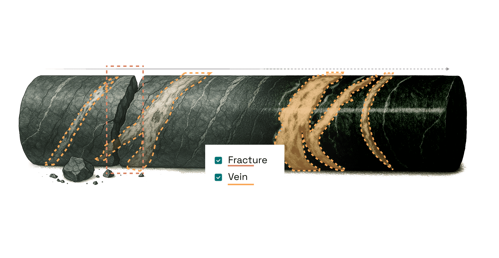
- Fractures
- Joint Set Analysis
- RQD
+ Product of your choice
Users
10
Image, data & results storage

Standard
150,000m
Analytics-Ready Data
Geotech Bundle
- Fractures
- Joint Set Analysis
- RQD
+ Product of your choice
Users
12
Image, data & results storage
Customer Success Manager

Premium
350,000m
Analytics-Ready Data
Geotech Bundle
- Fractures
- Joint Set Analysis
- RQD
+ Product of your choice
Users
14
Image, data & results storage
Customer Success Manager
Benefits
Enterprise provides ultimate flexibility
- Adjust your plan from year to year
to suit your needs - Move metres between your sites to maximise the value of each metre processed
- Each site can customise its own product suite
Enterprise Plus
400,000m
Up to 5 sites
Analytics-Ready Data
Geotech Bundle
- Fractures
- Joint Set Analysis
- RQD
Users
14 per site
Image, data & results storage
Customer Success Manager
Enterprise Elite
1,000,000m
Up to 10 sites
Analytics-Ready Data
Geotech Bundle
- Fractures
- Joint Set Analysis
- RQD
Users
14 per site
Image, data & results storage
Customer Success Manager
Why use
Datarock Core?
In the core shed
Looking to streamline operations in your core shed? Want more reliable, auditable logging data? Keen to ensure your geological and geotechnical insights directly support smarter decisions across the project?
Image agnostic
We can ingest any commonly collected core photos and can read most types of markup.
Connectivity
Seamlessly import and export data into and out of Datarock Core using our API to connect to your imagery storage and database.
Faster & smarter
Geologists and core shed teams can deploy Datarock Core to provide rapid results that can inform further logging, sampling and downstream decision-making.
Get more out of your photos
We can work with you and your team to optimise your core photography and mark-up practices to streamline automation and maximise performance.
Integration
Rapidly analyse core imagery to produce geotechnical and geological data at a cadence that integrates with your existing workflow.
Use Datarock Core to automate and augment your geological and geotechnical logging by leveraging core photography –flexibly integrating with your existing core shed people and processes.
New data from old holes
Do you have historic drill holes you’d like to revisit or extract new insights from? Are you dealing with core shed data that doesn’t meet your needs? Is your model impacted by gaps, inconsistencies, or missing information?
Upload
Datarock Core ingests, cleans, and validates large volumes of variable quality core imagery from most cloud-hosted locations.
Batch processing
Set up batch processing at a cadence that suits you – all at once or at regular intervals.
Supports modelling
Resource geologists, geotechnical engineers, and anyone who’s responsible for downstream modelling can fill gaps, increase coverage, and consistency of modelling data.
Answers from imagery
Define the datasets you need at the frequencies and scales your model requires – with the ability to update and re-export as your knowledge grows or priorities change.
Customer imagery services
No time to do it yourself? The Datarock team provides a full service to process your historic / backlog imagery and deliver you results fast.
Use Datarock Core to digitise, clean, and process large volumes of historical core photos into consistent, quantitative datasets that can be used to improve your models.
Benefits
Datarock Core will save you time and money – from the core shed to the block model.
01
Cost-effective
Accelerate resource-intensive tasks, freeing your technical team to focus on geoscience and engineering
02
Consistent
Improve logging consistency and quality and standardise data collection across sites
03
Fast
Generate geotechnical and geological insights in minutes unlocking faster decision making
04
Scalable
Datasets that scale to the size of your project, generating insights from pixel to deposit
05
Transparent
Create approvals, versioning and a visual audit trail for your core data
Our products
Browse this catalogue to view the range of products available with our Datarock Core subscriptions.
Our products use machine learning models that are trained to see rocks and extract valuable geological and geotechnical data from them. These products use our general models that we then tune to your specific deposit, maximising their performance on your rocks.
Analytics-Ready Data
Transform any raw core photograph into analytics-ready imagery.


Geotech Bundle
Your key geotech datasets included as standard.


+ More products
Select the right product for your geology, data or problem.


Advanced Geotech Bundle
If you need more Geotech solutions, this bundle is made for you.


Data Fusion
If imagery isn’t enough.
Geochemistry
Add your downhole geochemistry data to our core imagery analytics
workflows.

Mineralogy

Combine core imagery with commonly collected mineralogical datasets – MLA, XRD, FTIR, LIBS, TIMA, VNIR/SWIR.
Geophysics
Augment core imagery analytics with downhole geophysics datasets including gamma, mag sus and density.

Core Scanning
Combine core imagery analytics with mineralogy and elemental mapping from core scanning systems.

Televiewer (ATV/OTV)
Automate the generation of geotech data from televiewer and combine with your core imagery to further improve geotechnical insights.

Why Datarock?
27
M+
Metres of core analysed since 2020 — across exploration, resource, and geotech programmes.
Choosing the right subscription for you
Step 1 - How many metres?
Consider the projects and holes you want processed
- Historic holes
- Current/planned drilling
Step 2 - How many sites?
Choose the right base subscription for you
- Focusing on one project
- Enterprise – Rolling out across multiple sites
Step 3 - What products do you need?
Choose the products that support your business case
+ Add unlimited products to your subscription
- Analytics-Ready Data and Geotech Bundle included in every subscription
- Browse our catalogue for additional products on offer
- Need something unique to you? We also build bespoke products and data fusion
Step 4 - Need any add-ons?
Update your subscription as your needs change, at any time
+ Add-ons available:
- Metres
- Products
- Sites

